PLANNING APPLICATIONS 

24/1631/CPE - Certificate of existing lawfulness for use of land and buildings for a mix of agriculture and steel fabrication, which includes (but is not limited to) fabrication, alterations, welding, repairs, engineering and construction either in respect of existing or new parts, components or otherwise (Use Class B2) industrial use and incidental and ancillary uses

25/2163/FUL - Pulshays, Combe Raleigh, EX14 4UJ - erection of a timber outbuilding, installation of an air vent on the front elevation of dwelling and new flue on chimney

25/2164/LBC - Pulshays, Combe Raleigh, EX14 4UJ - installation of ecco stove, air vent on the front elevation and flue on chimney; replacement of flooring in dining room and erection of timber outbuilding 

25/2092/LBC - Little Thatch, Beacon, EX14 4TT - replace 1 no. window in kitchen and block up and render 1 no. window in pantry on west elevation of kitchen 

25/1078/MFUL - Old Spurtham Farm Otter Falls, New Road, Upottery, EX14 9QD - change of use of field and installation of 20 pitch bases for caravans for holiday use, access and parking surfaces, drainage, gas tanks, play equipment, bin store, sewage treatment plant, surface water drainage system and landscaping 

25/2437/FUL - Agricultural building near Higher Wick Farm, Wick, EX14 4TY - demolition of existing large agricultural buildings and erection of a new dwelling-house with access, parking and garden areas 

25/2484/FUL - Pulmans Farm, Beacon, EX14 4TX - proposed extension to the north-east elevation of the barn outbuilding to provide a toilet and shower room, and reinstatement of a section of boundary fencing along the western boundary of the site between the residential curtilage and adjoining agricultural land

fields

 Photographs courtesy of Colin Wright

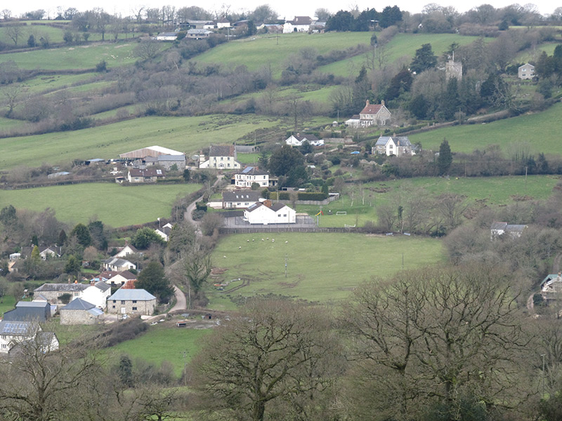
The parish of Luppitt comprises Luppitt village, Beacon, Wick and Shaugh and is set in the heart of picturesque East Devon, some 7 miles from the market town of Honiton. The parish borders the beautiful Otter Valley which is part of the Blackdown Hills Area of Outstanding Natural Beauty.

Luppitt is made up of a tapestry of small, family-run farms and has some 25 miles of roads and lanes, common land, upland grazing, farmland, public footpaths and bridleways. Luppitt is a thriving community with a Church, Village Hall, a pub, a Vihara (Buddhist monastery) and a brewery which makes the very successful Otter Ales. Luppitt boasts the famous Dumpdon Hill with an Iron Age fort which is National Trust and a Site of Special Scientific Interest (SSSI).

St Mary’s Church has an interesting Saxon font. A permanent Puzzle Bench, with many interesting facts about Luppitt, was erected in the Churchyard to commemorate the Millennium. Luppitt has many listed houses, several of which are mentioned in the Domesday Book.

Luppitt is a very active and social parish. Social activities centre on the Village Hall, the Church and pub. The village has a successful monthly magazine called The Luppitt Packet which is delivered free to every household in the parish and includes information of interest to the local community.